

Follow us on Google News

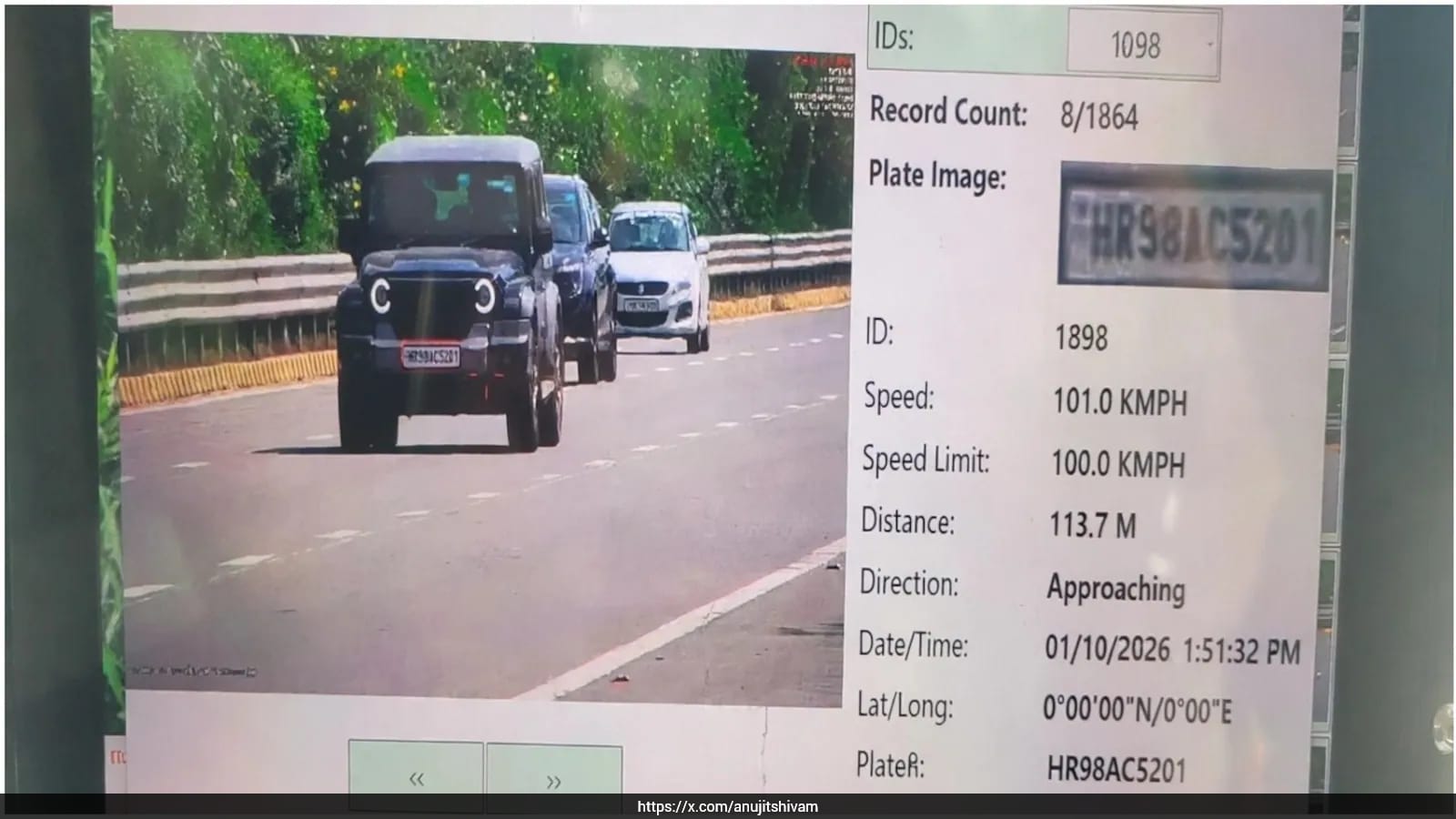
NOIDA: An electronic traffic challan issued for overspeeding on the Yamuna Expressway in Uttar Pradesh has raised questions over the technical accuracy of the digital enforcement system after it recorded the vehicle’s location in the Atlantic Ocean. The car was traveling on the expressway, yet the geographic coordinates listed on the fine placed it thousands of kilometers away in the sea near the western coast of Africa. A fine of Rs 2,000 was imposed on the vehicle owner, and the incident quickly drew widespread attention after images of the challan surfaced on social media.
A motorist named Anujit Shivam shared screenshots of his e-challan on the social media platform X. He stated that his car was moving at a speed of 101 kilometers per hour on the Yamuna Expressway. Since the permissible speed limit on the stretch is 100 kilometers per hour, the system generated a Rs 2,000 penalty for exceeding the limit by just one kilometer per hour.
Challan Records Zero-Zero Coordinates
The most striking aspect of the penalty notice is the location data attached to the violation. The document recorded the coordinates as 0 degrees north latitude and 0 degrees east longitude. Geographically, this point lies in the Atlantic Ocean off the western coast of Africa and is commonly referred to as the zero-zero coordinate.
This meant that at the exact time the car was being driven on the Yamuna Expressway, the automated system logged its position in the middle of an ocean. The discrepancy has cast doubt on the reliability of both the speed-recording mechanism and the location-tracking data used to issue digital fines.
Social Media Users Question Digital Verification
Following Anujit Shivam’s post, several social media users questioned the technical glitch and commented on the functioning of traffic cameras and automated challan systems. Many pointed out that when a penalty notice displays an impossible location, there must be a clear mechanism to verify the evidence before imposing a fine.
The e-challan framework is designed to identify traffic rule violators and enforce penalties transparently using speed cameras and digital tracking tools. However, the inclusion of erroneous geographic coordinates in this instance has prompted concerns regarding the accuracy of the data generated by the system.
Traffic Police Advise Contacting Helpline
After the matter gained traction online, the Noida Traffic Police responded to the post and advised the motorist to contact the e-challan helpline number to formally register his complaint and resolve the issue. However, it remains unclear what specific technical fault caused the Atlantic Ocean coordinates to appear on the notice, or whether the disputed challan has been investigated or canceled.
Without an expert technical review, the exact reason behind the error cannot be confirmed. In many digital mapping systems, zero-zero coordinates appear as default values when actual location data fails to transmit or process properly, though officials have not confirmed if this occurred in the present case. The episode underscores the need for thorough data verification within the e-challan network and prompt resolution of motorist grievances. Vehicle owners are advised to carefully check their registration numbers, timestamps, locations, and violation details on digital notices, and report any discrepancies to the concerned authorities for verification.